More Photos

Went camping Colorado at Spanish Peaks and Great Sand Dunes.  These first ones are from Zapata Waterfall where we actually camped.  It was mosquito infested but the respected the wind smoke and deet rule so it wasn't so bad.

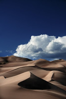
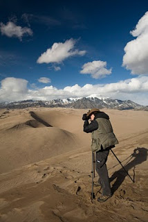
Then of course great sand dunes.  I was surprised by the quality of the view from the overlook but the hike to it while short was horrendous.  So terrible were the mosquitoes that Nick and I were forced to sprint for about a quarter mile of it.  Reminded me of the home country in the fields of North Dakota.

We didn't actually camp in Spanish Peaks but a neighboring wilderness area.  We were unimpressed for many reasons with the camping area.  There's a campground near the hike up west Spanish Peak that though it is without water looks to be the place to stay.

Great Sand Dunes National Park

Nestled up against the western side of the San De Cristo range is a most unexpected place here in Colorado, the Great Sand Dunes National Park. The entire first time experience is vaguely surreal and disorienting. As you approach from the south passing some of Colorado 14' mountains you watch them grow. They seem small and diminutive at first, especially in comparison to the mountains behind them, but as you near them you realize just how massive of dunes they are. Two of the dunes, High and Star Dunes, are the tallest in North America, the latter reaching up some +700" up from the San Luis Valley. The second, while ranging around 600" is the closest to you and much easier to reach certainly seems to be taller.

Thankfully the trail head and parking lot are rather close to the dunes, on the eastern side. The cars tend to be obscured from view by a little rise in the ground and tall bushes keeping the sight of such things from being too bothersome when enjoying the views later. From the trail head to the dunes is a bit of flat plains area that floods with water from the Medano C

reek during the spring and early summer. Adding to the surealness of area, this creek seems to have a tide as waves come strolling down it. These waves are caused by water building up and then breaking little sand walls in the stream. Unfortunately during the time of year when this is prevalent, the park tends to be busy making it hard to get purist shots of it.

Once you have crossed this you come to a dismaying wall of sand that is High Dune. The hike up this is a bit of work. You can either go plowing strait up as well you can or weave back and forth along the tops of smaller dunes until you reach the summit. The latter is advised if you choose to approach from the eastern side. A more scenic route can be found by following the creek bed to the south and then swinging west to head up the southern side of the dunes. This route is just littered with Prairie Sunflowers, which when I've ever come across them always face east (most frustrating). This way also provides excellent routes up ridges to the higher dunes. You can cut the walk short and head up for High Dune or can you continue on for a rather long hike to head up Star Dune. Continuing on Star Dune is a bit of day hike. It really is not all that far, but the constant up and down coupled with sand can be tiring. Complicating this is that during the summer the sand gets very very hot and like all mountain locations, storms are frequent in the afternoons. I remember on my first trip out here I went charging up the side of High Dune and about 3/4th of the way up I turned arou

nd and watched lighting strike just on the other side. Quite unsettling as you can imaging as you watch the storm front inch closer to you as you realize you are holding a large aluminum lightening rod that happens to double as a tripod. Of course in the winter none of these problems exist, but all the charming flowers are gone, as well as the insects.

The Dunes, especially in the lower areas, are filled with various insects. While I myself have yet to make any kind of real photographic study of them, they would be rather good subjects. Most are sizable for North American and rather slow moving. The light would be harsh, but considering the difficulties of getting enough light in macro, especially natural light, I think it could be forgiven. Unfortunately, the bane of all hiking, the mosquito, is present in late summer and fall in number. They can be easily avoided though, they stay near the creek bed and campground, and are practically non-existent on the dunes proper.

Something else to consider when planning for a trip out onto the dunes is wind. While you are the east side of the dunes you tend to have little to no wind. You are protected there by the dunes themselves, and the mountain range to the east. However once you near the summit of High Dune, the east blowing winds can really become trouble. They can kick up sand with such a ferocity as to make

any exposed skin scream and leave it red and angry like a bad sun burn. Bring clothing that can you cover all of your skin with and goggles. The blowing sand is bad for lenses and even worse if it makes into any moving part. It takes weeks of use and cleaning to get my tripod free of the stuff. I have a friend Alex Burke (to whom this photo of me must be given credit for) who tends to shoot 4x5. He complains with vehemence the problems of the dunes and the large format gear. I can only imagine the trouble as I hear sand within my own. The photos always make it worth it. Do not let the thread of blowing sand deter you, it is not a constant. Of the four trips I have made down to the dunes, the wind has only been a real problem once and non-existent other times. It was calm enough one occasion to sit down and wait for better clouds while reading Asimov.

Good cloud formation can be problem. They form on the mountains all around the valley during the morning and then blow in for early afternoon. They tend to come from the west, northwest, but it depends on the wind. Two wind systems collide over the dunes, which is part how they are created, but this collision can paralyze the clouds over the mountains leaving much of the sky dull empty.

Something else to consider when planning a trip the dunes, is the access they give you to the mountain range, especially Zapata Falls. You can also use it as a stopping point for a trip out to Wheeler Geologic Area.

For complete set of my photos of the area refer to:

my flickr

Photograph of me by Alex Burke:

flickr